What is Sir Creek and Why is it Important?
Sir Creek is a strip of water, where a river flows into the sea, which is in the uninhabited marshes of the Rann of Kutch. It leads to the Arabian Sea and practically divides the region of Kutch belonging to the Indian state of Gujarat and Sindh province of Pakistan. It is also marked by extremely harsh terrain that is mainly sandbanks, marshlands, and strong tidal currents with physical demarcation of a border being incredibly difficult.
This swampy ground is not significant in its own right, but in the ocean into which the creek empties. Under the international maritime law, an Exclusive Economic Zone (EEZ) becomes 200 nautical miles (approximately 370 kilometers) off the coastline of a country. The origin of the measurement of this zone is the land border. Unresolved status of Sir Creek has a direct influence on the delimiting of the maritime boundary and control over thousands of square kilometers of the sea and its resources remain in conflict.
This contentious maritime region is estimated to have high reserves of oil and natural gas, and it is a huge economic stakes to either country that gains control of this area. Moreover, the region is among the biggest fishing grounds in Asia and the absence of a demarcated boundary normally causes fishermen of both nations to be detained as they accidentally cross over to the waters of the other. The fact that fishermen are constantly arrested is a repetitive human element to the geopolitical conflict.
Security wise, the terrain is harsh and remote thus making the creek a weak point against illegal activities. The region has been an ever-present target of smugglers and terrorists trying to enter India. This is the same route that is thought to have been used by the perpetrators of the 2008 terror attacks in Mumbai to enter the country thus it can be seen that a strong security and surveillance is urgently required in this disputed zone.
The Colonial Muddle: Roots of the Disagreement
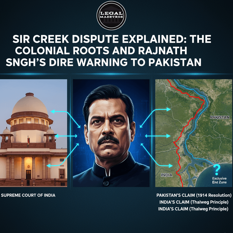
The cause of the Sir Creek controversy dates back to the early 20 th century during which the region belonged to the British India. The dispute is based on a legal document by the colonial government, that is, the Resolution of the Bombay Government of 1914. This solution was supposed to resolve a conflict between the head of the princely state of Kutch and the rulers of the Sindh province. However, the document had a very important contradiction which was the basis of the future conflict.
The trouble is that the text of the resolution did not match the map to which it was attached. The text of the resolution (paragraph 9) defines the boundary as being the mid-point of the creek. This meaning is the foundation of the Indian claim and concurs with one of the widely recognized international law principles regarding river delimitation. According to this principle, the border is supposed to be in the center of the principle navigation in the waterway.
But a map attached to the same resolution represents the boundary line in a different way. There is a mistake in the map, where it may seem a cartographical mistake, or perhaps a more liberal interpretation, which places the border on the eastern bank of the creek. Such an alignment would imply that the whole waterway of Sir Creek falls under the province of Sindh and subsequently, to Pakistan in the year 1947 after partitioning India. It is this very map which is presented by Pakistan as the main evidence behind its claim.
This anachronicity generated two entirely distinct and valid sounding claims. These competing interpretations were passed on to both India and Pakistan after independence turning a local administrative problem into an international border conflict. This legacy of mistrust and conflict has hovered around the lack of consistency between the legal text and the associated map, left by the colonial administration and is still witnessed to this date.
India’s and Pakistan’s Conflicting Stances
The Indian stand over the Sir Creek dispute is rooted in the wording of the 1914 resolution and one of the fundamental rules of international law which is the thalweg principle. According to this principle, a boundary between two states should be drawn along the middle of the main navigable channel also called the thalweg, when it is a waterway. India proposes that this is a normative and fair way of marking the rivers boundaries in the world and should be extended to Sir Creek.
New Delhi also argues that the text of the 1914 resolution that refers to the boundary as lying in the middle of the channel is the legally binding aspect of the agreement. The map, according to the Indian opinion, was only an illustrative appendix, and not the demarcation. Hence, India offers to mark the border in the middle of the creek so that the waterway will be split nearly at the center between the two states.
Pakistan, however, does not accept the thalweg principle, and grounds all its claim upon the map annexed to the resolution of 1914. They insist that the green line upon the map which establishes the boundary at least on the eastern bank of the creek, is the last and final decision of the British Indian government, and is a legally binding one. Based on this interpretation, the whole Sir Creek waterway is part of Pakistan.
Nor does Islamabad claim that the creek is a navigable river, but a tidal estuary, and consequently the principle of thalweg is inapplicable. They insist that the agreement was a closed case and the map was to be taken as the first evidence. Throughout the years, several series of negotiations have been conducted to solve the problem, yet these basic differences in interpretation have caused a continuous impasse.
Modern Security and Rajnath Singh’s Warning
The Sir Creek conflict has become a national security issue of India beyond its economic and legal aspects. The open and rugged nature of the creek makes it a perfect infiltration route by terrorists and smuggling route of narcotics and weapons into the country. India has therefore increased the surveillance and defense facilities in the area due to this security threat.